


Oultet/Lozerette/Les Sagne/Auriac

tyntyn
User
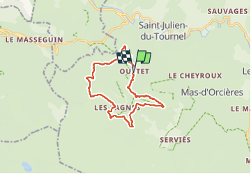

Length
12.8 km

Max alt
1340 m

Uphill gradient
433 m
Km-Effort
18.6 km

Min alt
1056 m

Downhill gradient
434 m
Boucle
Yes
Creation date :
2025-02-06 12:08:22.468
Updated on :
2025-02-07 19:03:12.36
4h27
Difficulty : Medium

FREE GPS app for hiking
 SityTrail
IGN / Geographical institutes
SityTrail Plus
The world is yours!
About
Trail Walking of 12.8 km to be discovered at Occitania, Lozère, Mont Lozère et Goulet. This trail is proposed by tyntyn.
Photos


Positioning
Country:
France
Region :
Occitania
Department/Province :
Lozère
Municipality :
Mont Lozère et Goulet
Location:
Saint-Julien-du-Tournel
Start:(Dec)
Start:(UTM)
553244 ; 4926078 (31T) N.
Comments